|
|
I strongly recommend going to Bassi Falls early in the spring,
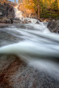
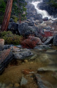
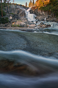
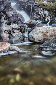
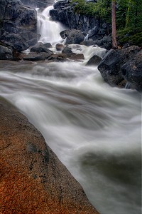
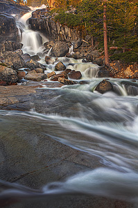
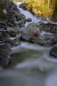
during snow run-off (late April through May). If you go during the summer, there will not be much of a waterfall left. But in the spring it is unbelievable. If you have not seen Bassi Falls at peak flow, you absolutely have to make the trip out to see it. Bassi Creek hurtles 109 ft. over a granite cliff, crashing over and through many large rocks. It is simply an awesome display of power and force.
It is an easy 10 minute walk from the parking area to the falls.
There is now an official, maintained trail leading to Bassi Falls.
It is very easy to follow, though once the trail reaches
an open area, it becomes indistinct crossing over the granite rock.
A line of rocks has been made so it is fairly easy to
continue following the trail to the waterfall.
It is not hard to find the falls anyway, because you can clearly hear it,
and eventually you will see it from a distance away.
This is a fairly popular area, so you probably will not be alone here, unless you come during the week.
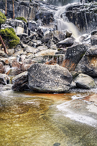
When you reach the base of Bassi Falls, you will be treated to
an awesome view of the entire 109 ft. cascade. Later in the summer,
there is really not much to see, as Bassi Creek becomes a
mere fragment of its former self. There
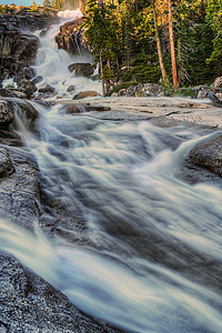
is a trail leading to the top of the falls, and I do recommend going up there if the creek is flowing strong. At the
top, you can stand at the brink of the falls and get an awesome view of the
creek hurtling over the falls. There is also a fabulous set of slides above the falls, as the creek descends rapidly down to the top of the waterfall. It is an incredible force of nature. But be very careful up there. If you fall in the creek, it is certain death if you go over the waterfall. Also, the trail to the top of the falls is not easy, as it ascends up a steep granite rock section. Going back down is quite tricky and potentially dangerous. Read my disclaimer.
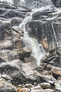
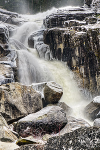
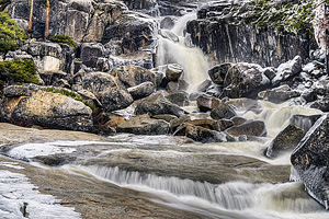
Bassi Falls is also a neat place to visit in the winter, although the water flow is not nearly as
spectacular as in the spring.
The waterfall was still nice to see, but the best part is the
experience of hiking here in the snow.
Some things you need to know if you plan on going to Bassi Falls
in the winter. Firstly, the forest road (12N32A) off Ice House Rd.
will be snowed in, so you will have to hike through the
snow from Ice House Rd. This adds 1.7 miles (1 way) to the hike.
Snowshoes or skis are definitely recommended. Secondly,
there was nowhere to park on Ice House Rd. I had to find a spot
about a half-mile away where we could park safely off the main road.
This added an additional 0.5 miles (1 way) to the hike. It was
well worth the effort, though.
In May 2007, I had a fun experience here as I led
Brian Hickey from KCRA CHANNEL 3 here to see Bassi Falls.
He was doing a story on waterfalls in the Sacramento
area, and interviewed me and videotaped me as I took photos of the
falls. My 5 minutes of fame (more like 2 minutes, actually).
You can see the video here.
One final note: Sunset is certainly
the best time to visit and photograph Bassi Falls, as you will get
the warm light shining on the falls at the end of the day. In the morning, the sun comes up right behind the falls and hits it early.
Update 5/2016: There is a new trail to Bassi Falls, and it is slightly longer than the easy 0.5 mile hike described here, but it is not difficult. It is two miles one way, well marked, and fairly easy, and begins from Millionaire campground, following the creek up to the big waterfall. When you turn off Ice House Rd, keep going straight past the initial turnoff (which is gated in the winter). There is a big parking area in a quarter mile, or you can drive down from there to the campground. It is a nice hike, and in fact may now be the only option to Bassi Falls.
16 Miles WNW Echo Summit CA (Elev. 5961 ft) This AfternoonA 10 percent chance of showers after 5pm. Partly sunny, with a high near 52. West southwest wind around 10 mph. TonightRain showers likely before 5am, then rain and snow showers likely. Cloudy, with a low around 34. Southwest wind 9 to 11 mph. Chance of precipitation is 70%. Little or no snow accumulation expected. FridayRain and snow showers likely before 11am, then rain showers. Some thunder is also possible. High near 42. West southwest wind 7 to 10 mph. Chance of precipitation is 80%. Little or no snow accumulation expected. Friday NightMostly cloudy, then gradually becoming mostly clear, with a low around 30. Northwest wind 6 to 8 mph becoming east northeast after midnight. SaturdayMostly sunny, with a high near 53. East northeast wind 5 to 9 mph becoming west in the morning. Saturday NightPartly cloudy, with a low around 34. SundaySunny, with a high near 57. Sunday NightMostly clear, with a low around 35. MondaySunny, with a high near 61. Monday NightClear, with a low around 40. TuesdaySunny, with a high near 65. Tuesday NightMostly clear, with a low around 41. WednesdaySunny, with a high near 64.
 Get Google Maps directions to trailhead
Zoom out on map to see all nearby waterfalls:
Get Google Maps directions to trailhead
Zoom out on map to see all nearby waterfalls:
Other waterfalls nearby:
Bassi Falls4.0 out of 4 reviews  
|