| Nevada Falls | Strenuous |

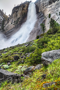
Image 1 of 3; Click arrow to scroll or click image to enlarge |
Location: Yosemite Village, Yosemite National Park, Mariposa County Stream: Merced River Alternate Names: Height: 594 ft. Access:   Distance: 6.4 miles (RT) Elevation: 4000 ft. (+2000 ft.) Season: Apr-Jul Form:  Lat/Long:37.72496, -119.53249 Directions:On Southside Drive, drive to Curry Village and park. Then take the free shuttle to Happy Isles, stop #16. Start walking up the paved trail to Nevada Falls. |


2 Miles S Yosemite CA (Elev. 7730 ft)
OvernightPartly cloudy, with a low around 37. Calm wind.
Wednesday
A 40 percent chance of showers and thunderstorms after 11am. Snow level 7700 feet rising to 8900 feet in the afternoon. Partly sunny, with a high near 49. Light and variable wind becoming west 5 to 10 mph in the morning.
Wednesday Night
A 20 percent chance of showers and thunderstorms before 11pm. Snow level 8500 feet lowering to 7700 feet after midnight . Mostly cloudy, with a low around 35. West northwest wind around 5 mph becoming calm.
Thursday
Partly sunny, with a high near 45. Light and variable wind becoming west southwest 5 to 10 mph in the afternoon.
Thursday Night
Mostly cloudy, with a low around 35. West southwest wind 5 to 15 mph.
Friday
A 50 percent chance of snow showers, mainly after 11am. Some thunder is also possible. Partly sunny, with a high near 40. West southwest wind 5 to 15 mph. New snow accumulation of less than a half inch possible.
Friday Night
A 10 percent chance of snow showers before 11pm. Some thunder is also possible. Partly cloudy, with a low around 28. West wind 10 to 15 mph becoming north northeast in the evening.
Saturday
Sunny, with a high near 46. North northwest wind around 10 mph becoming west in the morning. Winds could gust as high as 20 mph.
Saturday Night
Mostly clear, with a low around 33. West wind 5 to 10 mph becoming east southeast in the evening. Winds could gust as high as 15 mph.
Sunday
Sunny, with a high near 51. South southeast wind 5 to 10 mph becoming west southwest in the morning. Winds could gust as high as 15 mph.
Sunday Night
Mostly clear, with a low around 36. West wind 5 to 10 mph becoming northeast in the evening. Winds could gust as high as 15 mph.
Monday
Sunny, with a high near 55. North northwest wind 5 to 10 mph becoming west in the morning. Winds could gust as high as 15 mph.
Monday Night
Mostly clear, with a low around 38. West wind around 10 mph becoming northeast in the evening. Winds could gust as high as 15 mph.
| Silver Apron Falls | 0.50 miles | |
| Vernal Falls | 0.62 miles | |
| Illilouette Falls | 1.71 miles | |
| Staircase Falls | 2.36 miles | |
| Tenaya Falls | 2.42 miles | |
| Royal Arch Cascade | 2.65 miles | |
| Snow Creek Falls | 2.80 miles | |
| Merced River Falls | 2.85 miles | |
| Sentinel Falls | 3.40 miles | |
| Clark Fork Falls | 3.55 miles | |
| Lehamite Falls | 3.56 miles | |
| Bunnell Cascade | 3.61 miles | |
| Lower Yosemite Falls | 3.86 miles | |
| Upper Yosemite Falls | 4.05 miles | |
| Lower Pywiack Cascade | 4.64 miles | |
| Pywiack Cascade | 4.90 miles | |
| Echo Creek Falls | 5.41 miles | |
| Horsetail Falls | 5.55 miles | |
| Silverlace Falls | 5.67 miles | |
| Bridalveil Falls | 6.10 miles | |
| Ribbon Falls | 6.20 miles | |
| Upper Tenaya Creek Falls | 6.62 miles | |
| Widows Tears | 7.18 miles | |
| Silver Strand Falls | 7.40 miles | |
| Lower Washburn Lake Falls | 8.08 miles | |
| Tioga Pass Falls | 8.77 miles | |
| Upper Washburn Lake Falls | 8.91 miles | |
| Sacred Pool Falls | 9.36 miles | |
| Cascades | 9.58 miles | |
| Tamarack Falls | 9.74 miles | |
| Wildcat Falls | 9.80 miles | |
| Merced Peak Fork Falls | 9.95 miles |
| High Sierra | Waterfalls Home Page |