|
|
Easy |

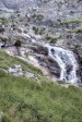
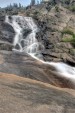
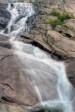
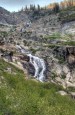
Image 1 of 4; Click arrow to scroll or click image to enlarge |
Location: Lodgepole, Sequoia National Park, Tulare County Stream: Marble Fork Kaweah River Alternate Names: Height: ~1200 ft. Access:   Distance: 3.8 miles (RT) Elevation: 6800 ft. (+600 ft.) Season: May-Sep Form:  Lat/Long:36.60886, -118.68964 Directions:Located at the Lodgepole campground, off Hwy 198 (27 miles north of Three Rivers). The trailhead is located at the bridge over the Marble Fork Kaweah River. |


2 Miles ENE Lodgepole CA (Elev. 9180 ft)
OvernightMostly cloudy, with a low around 33. East wind around 5 mph.
Wednesday
A chance of rain between 11am and 5pm, then a chance of showers and thunderstorms after 5pm. Snow level 9300 feet rising to 10200 feet in the afternoon. Partly sunny, with a high near 43. Wind chill values as low as 29. Southeast wind around 5 mph becoming southwest in the morning. Chance of precipitation is 40%.
Wednesday Night
A chance of rain before 8pm, then a chance of rain and snow between 8pm and 5am, then a slight chance of snow after 5am. Some thunder is also possible. Snow level 10100 feet lowering to 9200 feet after midnight . Mostly cloudy, with a low around 32. Wind chill values as low as 25. West northwest wind 5 to 10 mph becoming east after midnight. Chance of precipitation is 40%. Little or no snow accumulation expected.
Thursday
A slight chance of snow before 8am, then a slight chance of rain and snow showers between 8am and 11am, then a chance of rain showers after 11am. Some thunder is also possible. Snow level rising to 10200 feet in the afternoon. Partly sunny, with a high near 44. Wind chill values as low as 26. East wind 5 to 10 mph becoming west northwest in the morning. Chance of precipitation is 50%. Little or no snow accumulation expected.
Thursday Night
A slight chance of rain showers, mixing with snow after 8pm, then gradually ending. Some thunder is also possible. Snow level 9800 feet. Partly cloudy, with a low around 33. West northwest wind 5 to 10 mph becoming northeast after midnight. Chance of precipitation is 10%.
Friday
A 40 percent chance of showers and thunderstorms after 11am. Snow level 9300 feet rising to 10000 feet in the afternoon. Mostly sunny, with a high near 46. Northeast wind 5 to 10 mph becoming west in the afternoon. Winds could gust as high as 15 mph.
Friday Night
A slight chance of rain and snow showers before 11pm, then a chance of rain showers after 5am. Some thunder is also possible. Snow level 10000 feet lowering to 9500 feet. Partly cloudy, with a low around 32. West wind 5 to 10 mph becoming northeast after midnight. Winds could gust as high as 15 mph. Chance of precipitation is 30%. Little or no snow accumulation expected.
Saturday
A chance of rain and snow showers before 8am, then snow showers likely. Some thunder is also possible. Mostly cloudy, with a high near 37. East wind 5 to 15 mph becoming west southwest in the afternoon. Winds could gust as high as 25 mph. Chance of precipitation is 60%. New precipitation amounts between a quarter and half of an inch possible.
Saturday Night
Snow showers likely before 11pm, then a chance of snow after 11pm. Some thunder is also possible. Mostly cloudy, with a low around 22. West southwest wind 10 to 15 mph, with gusts as high as 20 mph. Chance of precipitation is 60%.
Sunday
Snow likely before 11am, then snow showers likely after 11am. Some thunder is also possible. Mostly cloudy and cold, with a high near 28. West southwest wind around 10 mph, with gusts as high as 20 mph. Chance of precipitation is 70%.
Sunday Night
A 40 percent chance of snow. Mostly cloudy, with a low around 23. West wind 5 to 10 mph becoming east in the evening. Winds could gust as high as 15 mph.
Monday
A 30 percent chance of snow. Partly sunny, with a high near 35. East wind 5 to 10 mph becoming west southwest in the afternoon. Winds could gust as high as 15 mph.
Monday Night
A 20 percent chance of snow. Mostly cloudy, with a low around 28. West southwest wind around 5 mph becoming southeast after midnight.
| Marble Fork Kaweah Falls | 1.22 miles | |
| Mehrten Creek Falls | 2.50 miles | |
| Panther Creek Falls | 5.07 miles | |
| Elizabeth Pass Falls | 5.11 miles | |
| Lone Pine Creek Falls | 5.24 miles | |
| Middle Lone Pine Creek Falls | 5.83 miles | |
| Upper Lone Pine Creek Falls | 6.13 miles | |
| Lower Hamilton Lakes Falls | 6.25 miles | |
| Granite Spring Falls | 6.47 miles | |
| Middle Hamilton Lakes Falls | 6.51 miles | |
| Marble Falls | 6.69 miles | |
| Tamarack Lake Falls | 6.96 miles | |
| Middle Fork Kaweah Falls | 7.18 miles | |
| Cascade Creek Falls | 7.29 miles | |
| Hamilton Lakes Falls | 7.36 miles | |
| Lower Nine Lake Basin Falls | 8.57 miles | |
| Stoney Creek Falls | 8.88 miles | |
| Nine Lake Basin Falls | 9.13 miles |
| High Sierra | Waterfalls Home Page |