|
|
Easy |

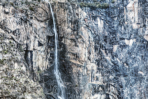
Image 1 of 2; Click arrow to scroll or click image to enlarge |
Location: Hetch Hetchy Reservoir, Yosemite National Park, Tuolumne County Stream: Falls Creek Alternate Names: Height: ~800 ft. Access:   Distance: 4.6 miles (RT) Elevation: 3800 ft. (+300 ft.) Season: Apr-Jun Form:  Lat/Long:37.96384, -119.77264 Directions:Drive to Hetch Hetchy Reservoir, one mile west of Big Oak Flat park entrance. The reservoir is 16 miles along Hetch Hetchy Rd. |


18 Miles NNW Yosemite Valley CA (Elev. 5981 ft)
This AfternoonShowers and possibly a thunderstorm. Snow level 6500 feet. High near 44. West wind around 10 mph, with gusts as high as 15 mph. Chance of precipitation is 90%. New rainfall amounts between a tenth and quarter of an inch, except higher amounts possible in thunderstorms.
Tonight
A chance of rain showers before 10pm, then a chance of snow showers between 10pm and 11pm. Some thunder is also possible. Mostly cloudy during the early evening, then gradual clearing, with a low around 32. West wind around 5 mph becoming east in the evening. Chance of precipitation is 40%. Little or no snow accumulation expected.
Saturday
Increasing clouds, with a high near 54. Wind chill values as low as 29 early. Light and variable wind becoming west southwest 5 to 10 mph in the morning.
Saturday Night
Mostly cloudy, then gradually becoming mostly clear, with a low around 38. West wind around 5 mph becoming calm.
Sunday
Sunny, with a high near 58. Light and variable wind becoming west southwest 5 to 10 mph in the afternoon.
Sunday Night
Mostly clear, with a low around 39. West wind 5 to 10 mph becoming light and variable in the evening.
Monday
Sunny, with a high near 63. East northeast wind 5 to 10 mph becoming west southwest in the morning.
Monday Night
Clear, with a low around 43. West wind 5 to 10 mph becoming northeast in the evening.
Tuesday
Sunny, with a high near 64. East northeast wind 5 to 10 mph becoming west southwest in the morning. Winds could gust as high as 15 mph.
Tuesday Night
Clear, with a low around 43. West wind around 10 mph becoming east northeast in the evening. Winds could gust as high as 15 mph.
Wednesday
Sunny, with a high near 66. East northeast wind around 10 mph becoming west southwest in the morning. Winds could gust as high as 15 mph.
Wednesday Night
Mostly clear, with a low around 44. West wind around 10 mph becoming east northeast in the evening. Winds could gust as high as 15 mph.
Thursday
Sunny, with a high near 63. Southeast wind around 10 mph becoming west southwest in the morning. Winds could gust as high as 20 mph.
| Hetch Hetchy Falls | 0.23 miles | |
| Wapama Falls | 0.38 miles | |
| Lower Falls Creek Falls | 1.79 miles | |
| Tiltill Creek Falls | 2.53 miles | |
| Far Lower Rancheria Falls | 2.81 miles | |
| Lower Rancheria Falls | 2.97 miles | |
| Upper Frog Creek Falls | 3.02 miles | |
| Rancheria Falls | 3.34 miles | |
| Middle Frog Creek Falls | 3.36 miles | |
| Frog Creek Falls | 3.41 miles | |
| Upper Eleanor Creek Falls | 3.78 miles | |
| Eleanor Creek Falls | 3.92 miles | |
| Bartlett Creek Falls | 4.70 miles | |
| Far Upper Eleanor Creek Falls | 4.74 miles | |
| Kibbie Creek Falls | 5.38 miles | |
| Middle Falls Creek Falls | 5.41 miles | |
| Branigan Lake Falls | 5.64 miles | |
| Falls Creek Falls | 6.03 miles | |
| Preston Falls | 7.92 miles | |
| Upper Morrison Creek Falls | 8.06 miles | |
| Morrison Creek Falls | 8.46 miles | |
| Kibbie Ridge Falls | 9.12 miles | |
| East Fork Cherry Creek Falls | 9.35 miles | |
| Far Lower Cherry Creek Canyon Falls | 9.38 miles | |
| Lower Cherry Creek Canyon Falls | 9.40 miles | |
| Upper Cherry Creek Canyon Falls | 9.43 miles | |
| Middle Cherry Creek Canyon Falls | 9.49 miles | |
| Cherry Bomb Falls | 9.57 miles | |
| Lower West Cherry Creek Falls | 9.81 miles |
| High Sierra | Waterfalls Home Page |