|
|
Easy |

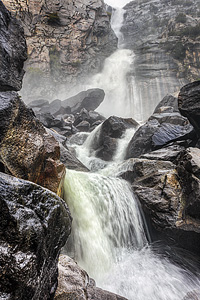
Image 1 of 2; Click arrow to scroll or click image to enlarge |
Location: Hetch Hetchy Reservoir, Yosemite National Park, Tuolumne County Stream: Falls Creek Alternate Names: Height: ~1300 ft. Access:   Distance: 4.6 miles (RT) Elevation: 3800 ft. (+300 ft.) Season: Apr-Jun Form:  Lat/Long:37.96609, -119.76604 Directions:Drive to Hetch Hetchy Reservoir, one mile west of Big Oak Flat park entrance. The reservoir is 16 miles along Hetch Hetchy Rd. |


18 Miles NNW Yosemite Valley CA (Elev. 5981 ft)
TonightCloudy, with a low around 40. Calm wind.
Friday
A chance of rain, then showers likely and possibly a thunderstorm after 11am. Snow level 6700 feet. Mostly cloudy, with a steady temperature around 42. Light west wind becoming west southwest 5 to 10 mph in the morning. Winds could gust as high as 15 mph. Chance of precipitation is 60%. New rainfall amounts between a tenth and quarter of an inch, except higher amounts possible in thunderstorms.
Friday Night
Rain likely before 10pm, then rain and snow likely between 10pm and 11pm, then snow after 11pm. Low around 34. West southwest wind around 5 mph becoming calm in the evening. Chance of precipitation is 80%. New snow accumulation of less than a half inch possible.
Saturday
Snow before 11am, then snow showers after 11am. Some thunder is also possible. High near 40. Wind chill values as low as 29. Calm wind becoming west southwest around 5 mph in the afternoon. Chance of precipitation is 90%. New snow accumulation of around an inch possible.
Saturday Night
Snow showers likely before 11pm, then a chance of snow after 11pm. Some thunder is also possible. Mostly cloudy, with a low around 31. West southwest wind around 5 mph becoming calm in the evening. Chance of precipitation is 70%. New snow accumulation of less than one inch possible.
Sunday
A chance of snow before 2pm, then a chance of rain. Mostly cloudy, with a high near 44. Calm wind becoming west southwest around 5 mph in the afternoon. Chance of precipitation is 50%. New snow accumulation of less than a half inch possible.
Sunday Night
Partly cloudy, with a low around 34. West wind around 5 mph becoming east northeast after midnight.
Monday
Sunny, with a high near 59. East northeast wind around 5 mph becoming west southwest in the morning.
Monday Night
Mostly clear, with a low around 41. West wind 5 to 10 mph becoming east northeast in the evening.
Tuesday
Sunny, with a high near 64. East northeast wind 5 to 10 mph becoming west southwest in the morning.
Tuesday Night
Partly cloudy, with a low around 45. West southwest wind around 5 mph becoming east northeast in the evening.
Wednesday
A 20 percent chance of showers and thunderstorms. Mostly sunny, with a high near 63. East northeast wind 5 to 10 mph becoming west southwest in the afternoon.
Wednesday Night
A 10 percent chance of rain. Partly cloudy, with a low around 45. West southwest wind around 5 mph becoming east northeast in the evening.
| High Sierra | Waterfalls Home Page |