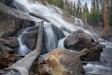
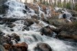
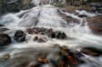
Minaret Falls Easy


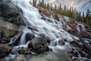
Image 1 of 5;
Click arrow to scroll or click image to enlarge
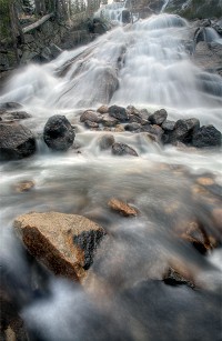
Location: Mammoth Lakes, Devils Postpile National Monument, Inyo National Forest, Madera County
Stream: Minaret Creek
Alternate Names:

Height: ~250 ft.
Access:   hike   dog  
Distance: 2.6 miles (RT)
Elevation: 7600 ft. (+100 ft.)
Season: Jun-Sep
Form:   cascade
Lat/Long:37.64058, -119.09140
Directions:From Mammoth Lakes, drive 13 miles on Hwy 203 to Devils Postpile Natl. Monument. Turn into the Devils Postpile (ranger station) area. There is a fee to enter the Monument. There is also a mandatory shuttle bus unless you are camping or are handicapped.

The second best waterfall in the Eastern Sierra is only about a mile or so upstream from the best waterfall. Minaret Falls cascades about 250 ft. or so from snowmelt in the Minaret mountain range, down into the Middle Fork of the San Joaquin River. It is incredibly impressive, and spans out very wide, falling in many little waterfall rivulets down the mountain side. You can get right up beside the falls and feel the mist in your face. It is an awesome experience.

To reach Minaret Falls, begin hiking south (away from the falls) from the Devils Postpile parking area (at the ranger station). After a short distance, you will come to a bridge across the river, then start hiking back upstream to Minaret Falls. The trail is well-signed.

When you reach the waterfall, you will be at the base of the falls. You can easily climb up to get better views of the upper section. To get to the very top of the falls might be too difficult, as you will have to find a way up and around the granite cliff.

6 Miles W Mammoth Lakes CA (Elev. 8071 ft)

Today
Mostly sunny and cold, with a high near 31. Southwest wind 10 to 15 mph, with gusts as high as 25 mph.
Tonight
Partly cloudy, with a low around 14. Southwest wind 10 to 15 mph.
Monday
Sunny, with a high near 44. Southwest wind 10 to 15 mph, with gusts as high as 20 mph.
Monday Night
Partly cloudy, with a low around 21. Breezy, with a southwest wind 15 to 20 mph, with gusts as high as 25 mph.
Tuesday
Sunny, with a high near 47. West wind around 15 mph, with gusts as high as 20 mph.
Tuesday Night
Mostly clear, with a low around 21. West wind 10 to 15 mph becoming north in the evening. Winds could gust as high as 20 mph.
Wednesday
Sunny, with a high near 47. North northeast wind 10 to 15 mph, with gusts as high as 20 mph.
Wednesday Night
Mostly clear, with a low around 21. North northeast wind around 15 mph, with gusts as high as 20 mph.
Thursday
Sunny, with a high near 47. North northeast wind around 15 mph, with gusts as high as 20 mph.
Thursday Night
Partly cloudy, with a low around 25. North northeast wind 10 to 15 mph, with gusts as high as 20 mph.
Friday
Sunny, with a high near 51. North northeast wind 10 to 15 mph becoming south southeast in the morning. Winds could gust as high as 20 mph.
Friday Night
Mostly clear, with a low around 28. West wind 10 to 15 mph becoming north in the evening. Winds could gust as high as 20 mph.
Saturday
Sunny, with a high near 54. Northeast wind 10 to 15 mph becoming south southwest in the morning. Winds could gust as high as 20 mph.

Get Google Maps directions to trailhead

Zoom out on map to see all nearby waterfalls:

Other waterfalls nearby:

Sotcher Lake Falls 1.62 miles
Upper Minaret Falls 1.95 miles
Far Upper Minaret Falls 2.24 miles
Rainbow Falls 2.70 miles
Middle King Creek Falls 2.70 miles
King Creek Falls 2.70 miles
Upper King Creek Falls 2.98 miles
Lower Rainbow Falls 3.14 miles
Minaret Lake Falls 3.47 miles
Rosalie Lake Falls 3.68 miles
Shadow Lake Falls 4.25 miles
Shadow Creek Falls 4.40 miles
Upper Shadow Creek Falls 4.65 miles
Mammoth Creek Falls 4.71 miles
Twin Falls 4.76 miles
Lower Mammoth Creek Falls 4.77 miles
Middle Fork San Joaquin River Falls 4.80 miles
Lower Nydiver Lakes Falls 5.09 miles
Upper Nydiver Lakes Falls 5.27 miles
Ediza Lake Falls 5.30 miles
East Garnet Lake Falls 5.84 miles
Garnet Lake Falls 6.07 miles
Middle Garnet Lake Falls 6.20 miles
Lower Garnet Lake Falls 6.24 miles
Ruby Lake Falls 6.72 miles
Dike Creek Falls 6.79 miles
Lower Dike Creek Falls 6.87 miles
Middle North Fork San Joaquin River Falls 6.94 miles
Iron Creek Falls 7.03 miles
Hemlock Crossing Falls 7.06 miles
Emerald Lake Falls 7.08 miles
Thousand Island Lake Falls 7.27 miles
Long Creek Falls 7.33 miles
Upper Lake Catherine Falls 7.55 miles
Middle Lake Catherine Falls 7.55 miles
Lake Catherine Falls 7.60 miles
Upper North Fork San Joaquin River Falls 7.86 miles
Ritter Lakes Falls 7.89 miles
Lower Twin Island Lakes Falls 8.04 miles
North Fork San Joaquin River Falls 8.09 miles
Lower North Fork San Joaquin River Falls 8.23 miles
Twin Island Lakes Falls 8.23 miles
Lower Bench Canyon Falls 8.33 miles
Horsetail Falls 8.59 miles
Tatum Falls 8.92 miles
Bench Canyon Falls 8.98 miles

High Sierra Waterfalls Home Page