| Helmcken Falls | Easy |

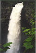
Image 1 of 1; Click arrow to scroll or click image to enlarge |
Location: Wells Gray Provincial Park, Clearwater region Stream: Murtle River Alternate Names: Height: 460 ft. (140.2 m) Access:    Distance: 2 miles (RT) (hike) (3.2 km) Elevation: Season: May-Oct Form:  Lat/Long:51.954012, -120.176821 Directions:Follow Clearwater Valley road that enters Wells Gray Park north of Clearwater (km 40.9). The trailhead is just a few miles inside the park entrance. You can also drive right to a viewpoint of the falls. Continue on main road just past trailhead (km 42.2). |

There are many other waterfalls in Wells Gray Park. In fact, there are about 25 or so accessible falls, and many more that are inaccessible or can only be reached by boat. We only had a few days to spend there and so did not have time to explore very many of them. Some day I will return and check out these other waterfalls. Some that look particularly interesting and fairly easy to get to are: Canim Falls (Canim River), Deception Falls (Deception Crk), Sylvia Falls (Mahood River), Sticta Falls (Falls Crk), Majerus Falls (Murtle River), and Horseshoe Falls (Murtle River). In addition, 600 ft. Silvertip Falls is located along Spahats Creek Road (off Clearwater Valley Road at km 11.2), just past the visitor centre.
| Dawson Falls | 3.06 miles | |
| Goodwin Falls | 3.07 miles | |
| Sylvia Falls | 3.10 miles |
| High Country | Waterfalls Home Page |