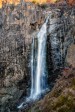
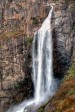
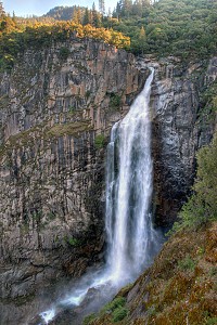
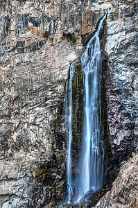
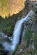
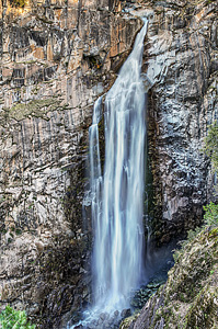
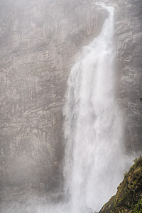
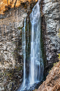
Feather Falls Moderate


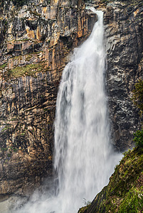
Image 1 of 10;
Click arrow to scroll or click image to enlarge
Location: Oroville, Feather Falls Scenic Area, Plumas National Forest, Butte County
Stream: Fall River
Alternate Names:

Height: 410 ft.
Access:   hike   dog   bike  
Distance: 7.9 miles (loop)
Elevation: 2500 ft. (-1000 ft., +1000 ft.)
Season: year-round
Form:   plunge
Lat/Long:39.64310, -121.27433
Directions:From Oroville, take Hwy #162 east (Olive Hwy) for 6.7 miles, turn right on Forbestown Road for 6.3 miles, turn left on Lumpkin Road for 11.4 miles to the signed turnoff for Feather Falls. Turn left at sign and drive 1.5 miles to the trailhead.

Feather Falls is one of my favourite hikes. I have been here many times now, in the spring when the falls is raging and at low flow in the fall. It is a spectacular waterfall, plunging 410 ft. along the Fall River. Feather Falls flows year-round, but is most impressive in April, when the snow is melting. Outside of Yosemite, this is one of the best waterfalls in California.

The Feather Falls hike is a very popular one, so I recommend coming here in the early morning. When I was here on a Saturday in early May, I arrived at the falls for sunrise, so I had the waterfall all to myself. But on the hike back, I must have passed about 70 other hikers on the way to see the falls. It was crazy. And it was obvious none of them had read my website because they were all going in the wrong direction. Feather Falls is a loop hike, the upper loop is 4.5 miles and the lower one 3.5 miles. All the guidebooks, for some mysterious reason, recommend hiking the lower loop into the falls and the upper loop on the return. I think, also, that people see the sign at the junction that says the falls is 3.3 miles or 4.5 miles and so they take the shorter one naturally. But even though it is a mile shorter, it does not take any less time, and is more difficult. I recommend taking the longer 4.5 mile loop to the falls (which is mostly all downhill), and the shorter 3.5 mile loop on the return. If you do it this way, you will have 7.0 miles of downhill hiking, and only 2.0 miles of uphill hiking on the return. The last 2.0 miles will be steep, but is not really all that bad, and is not any steeper than if you had gone in the other direction.

There is a path that leads to the top of Feather Falls, where you can look down from the brink as it plunges down into the canyon. It is definitely a sight worth seeing. But be careful around this area. The rocks can be very slippery, and people have died here before. It is not a place to take children! There are also swimming holes at the top of the falls, for later in the summer.

I was anxious to return to Feather Falls in '08 for a couple reasons. The first is because of the huge wildfire that occurred here in 2008, causing the trail to be closed for most of the summer. There was damage to the overlook as well as many fallen trees along the trail. I hiked here in the winter after it re-opened. The burnt areas were definitely noticeable, but it was certainly not awful. There were a few fallen trees but not too many, and the overlook was completely restored and damage was not noticeable except for a few burnt boards that were replaced.

The second reason I wanted to get back to Feather Falls was to determine its true height. I had read on Bryan Swan and Dean Goss' world waterfalls website that they had determined that Feather Falls was not 640 ft. high, as is widely reported. Indeed, after examining the topo maps, it seemed to be more in the neighborhood of 400 ft. high. I wanted to measure it more officially with my laser rangefinder and clinometer to confirm this difference of opinion. I found that indeed Feather Falls is only 410 ft. high. It is definitely *not* 640 ft. high, and certainly nowhere near being the 6th highest waterfall in the U.S. (which is also widely reported). This came as a complete shock and big disappointment to me. I had always just assumed the 640 figure was accurate. Who came up with that figure and how? But the truth is now revealed: Feather Falls true height is 410 ft.

14 Miles ESE Concow CA (Elev. 2224 ft)

Tonight
Mostly clear, with a low around 49. East southeast wind around 5 mph becoming calm after midnight.
Thursday
A 30 percent chance of showers, mainly after 4pm. Increasing clouds, with a high near 57. Light and variable wind becoming south southwest 5 to 10 mph in the morning. New precipitation amounts of less than a tenth of an inch possible.
Thursday Night
Showers likely, mainly before 11pm. Mostly cloudy, with a low around 48. South wind 7 to 9 mph. Chance of precipitation is 70%. New precipitation amounts of less than a tenth of an inch possible.
Friday
A chance of showers, then showers likely and possibly a thunderstorm after 11am. Mostly cloudy, with a high near 55. South wind 6 to 8 mph becoming west in the afternoon. Chance of precipitation is 70%. New rainfall amounts between a tenth and quarter of an inch, except higher amounts possible in thunderstorms.
Friday Night
Mostly clear, with a low around 44. West wind 5 to 9 mph becoming light and variable.
Saturday
Sunny, with a high near 61.
Saturday Night
Mostly clear, with a low around 47.
Sunday
Sunny, with a high near 64.
Sunday Night
Mostly clear, with a low around 49.
Monday
Sunny, with a high near 65.
Monday Night
Clear, with a low around 50.
Tuesday
Sunny, with a high near 67.
Tuesday Night
Partly cloudy, with a low around 49.

Get Google Maps directions to trailhead

Zoom out on map to see all nearby waterfalls:

Other waterfalls nearby:

Frey Creek Falls 1.27 miles
Upper Frey Creek Falls 1.95 miles
Curtain Falls 2.10 miles
Lower Seven Falls 4.39 miles
Seven Falls 4.52 miles
Cascade Creek Falls 5.26 miles
French Creek Falls 6.53 miles
Upper French Creek Falls 6.61 miles
Little North Fork Falls 6.62 miles

Shasta Cascade Waterfalls Home Page