|
|
Easy |

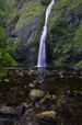
Image 1 of 1; Click arrow to scroll or click image to enlarge |
Location: Columbia River Gorge National Scenic Area, Multnomah Falls, Oneonta Gorge, Multnomah County Stream: Horsetail Creek Alternate Names: Height: 192 ft. Access:    Distance: n/a Elevation: 50 ft. Season: year-round Form:  Lat/Long:45.58935, -122.06849 Directions:Along I-84, take exit 28 at Bridal Veil (or exit 35 at Dodson if traveling west on I-84). Drive east along the Columbia Gorge Scenic Hwy for 5.5 miles to the signed turnout for Horsetail Falls. |

2 Miles SW Skamania WA (Elev. 591 ft)
TodaySunny, with a high near 65. Windy, with an east northeast wind 22 to 25 mph, with gusts as high as 36 mph.
Tonight
Mostly clear, with a low around 47. Breezy, with an east northeast wind 14 to 18 mph, with gusts as high as 26 mph.
Saturday
A 50 percent chance of showers after 11am. Increasing clouds, with a high near 65. East northeast wind 11 to 13 mph becoming west southwest in the afternoon. Winds could gust as high as 20 mph. New precipitation amounts between a tenth and quarter of an inch possible.
Saturday Night
Showers. Low around 42. Breezy, with a west southwest wind 14 to 17 mph, with gusts as high as 25 mph. Chance of precipitation is 90%. New precipitation amounts between a tenth and quarter of an inch possible.
Sunday
Showers likely, mainly before 11am. Partly sunny, with a high near 55. West southwest wind around 10 mph. Chance of precipitation is 60%.
Sunday Night
Mostly clear, with a low around 37.
Monday
Sunny, with a high near 65.
Monday Night
Partly cloudy, with a low around 45.
Tuesday
Mostly sunny, with a high near 67.
Tuesday Night
A chance of showers, mainly after 11pm. Mostly cloudy, with a low around 44.
Wednesday
A chance of showers. Partly sunny, with a high near 60.
Wednesday Night
A chance of showers. Mostly cloudy, with a low around 45.
Thursday
Showers likely. Mostly cloudy, with a high near 54.
| Ponytail Falls | 0.02 miles | |
| Lower Oneonta Falls | 0.30 miles | |
| Middle Oneonta Falls | 0.35 miles | |
| Oneonta Falls | 0.52 miles | |
| Triple Falls | 0.80 miles | |
| Weisendanger Falls | 2.32 miles | |
| Dutchman Falls | 2.35 miles | |
| Ecola Falls | 2.39 miles | |
| Multnomah Falls | 2.68 miles | |
| Fairy Falls | 3.25 miles | |
| Wahkeena Falls | 3.29 miles | |
| Elowah Falls | 4.22 miles | |
| Upper McCord Creek Falls | 4.26 miles | |
| Upper Coopey Falls | 5.38 miles | |
| Coopey Falls | 5.44 miles | |
| Upper Bridal Veil Falls | 6.26 miles | |
| Bridal Veil Falls | 6.39 miles | |
| Wahclella Falls | 6.54 miles | |
| Munra Falls | 6.66 miles | |
| Upper Munra Falls | 7.14 miles | |
| Shepperds Dell Falls | 7.33 miles | |
| Latourell Falls | 8.75 miles | |
| Lower Ruckel Creek Falls | 8.83 miles | |
| Upper Latourell Falls | 9.07 miles | |
| Metlako Falls | 9.45 miles | |
| Lower Punch Bowl Falls | 9.47 miles | |
| Punch Bowl Falls | 9.47 miles | |
| Loowit Falls | 9.81 miles |
| Columbia River Gorge | Waterfalls Home Page |