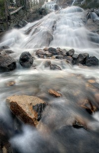
| Minaret Falls | Easy |

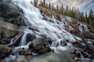
Image 1 of 5; Click arrow to scroll or click image to enlarge |
Location: Mammoth Lakes, Devils Postpile National Monument, Inyo National Forest, Madera County Stream: Minaret Creek Alternate Names: Height: ~250 ft. Access:   Distance: 2.6 miles (RT) Elevation: 7600 ft. (+100 ft.) Season: Jun-Sep Form:  Lat/Long:37.64058, -119.09140 Directions:From Mammoth Lakes, drive 13 miles on Hwy 203 to Devils Postpile Natl. Monument. Turn into the Devils Postpile (ranger station) area. There is a fee to enter the Monument. There is also a mandatory shuttle bus unless you are camping or are handicapped. |


6 Miles W Mammoth Lakes CA (Elev. 8071 ft)
This AfternoonA 10 percent chance of showers and thunderstorms after 5pm. Mostly sunny, with a high near 54. Southwest wind around 5 mph, with gusts as high as 15 mph.
Tonight
A 10 percent chance of showers and thunderstorms before 8pm. Mostly cloudy, with a low around 28. Southwest wind around 5 mph becoming calm in the evening. Winds could gust as high as 15 mph.
Wednesday
Showers likely and possibly a thunderstorm before 2pm, then rain likely between 2pm and 5pm, then a chance of showers and thunderstorms after 5pm. Mostly cloudy, with a high near 50. Wind chill values as low as 31 early. Calm wind becoming west southwest around 5 mph. Chance of precipitation is 60%. New rainfall amounts of less than a tenth of an inch, except higher amounts possible in thunderstorms.
Wednesday Night
A chance of showers and thunderstorms before 8pm, then a chance of rain between 8pm and 11pm. Cloudy, then gradually becoming partly cloudy, with a low around 29. Calm wind becoming north northeast around 5 mph. Winds could gust as high as 15 mph. Chance of precipitation is 40%.
Thursday
A 40 percent chance of showers and thunderstorms after 11am. Partly sunny, with a high near 51. Northeast wind around 5 mph, with gusts as high as 15 mph.
Thursday Night
A 10 percent chance of showers and thunderstorms before 11pm. Partly cloudy, with a low around 29. North northeast wind around 5 mph becoming calm.
Friday
A 40 percent chance of showers and thunderstorms after 11am. Mostly sunny, with a high near 53. Calm wind becoming southwest around 5 mph in the afternoon. Winds could gust as high as 25 mph.
Friday Night
A chance of showers and thunderstorms before 11pm, then a slight chance of rain after 11pm. Mostly cloudy, with a low around 31. Southwest wind around 5 mph, with gusts as high as 25 mph. Chance of precipitation is 30%.
Saturday
A chance of rain and snow showers before 11am, then rain between 11am and 2pm, then snow showers after 2pm. Some thunder is also possible. Snow level 9000 feet lowering to 8100 feet in the afternoon . High near 40. Southwest wind 5 to 10 mph, with gusts as high as 30 mph. Chance of precipitation is 80%. New precipitation amounts between a quarter and half of an inch possible.
Saturday Night
Snow showers likely before 11pm, then a chance of snow after 11pm. Some thunder is also possible. Mostly cloudy, with a low around 21. West southwest wind 5 to 10 mph, with gusts as high as 30 mph. Chance of precipitation is 60%.
Sunday
Snow showers likely. Some thunder is also possible. Mostly cloudy, with a high near 36. West wind 5 to 10 mph becoming north in the morning. Winds could gust as high as 25 mph. Chance of precipitation is 70%.
Sunday Night
A 30 percent chance of snow. Mostly cloudy, with a low around 23. North wind around 5 mph, with gusts as high as 25 mph.
Monday
A slight chance of rain showers and snow. Some thunder is also possible. Partly sunny, with a high near 43. North wind around 5 mph, with gusts as high as 25 mph. Chance of precipitation is 20%.
| High Sierra | Waterfalls Home Page |