GoodGood   Pfeiffer Falls Easy


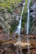
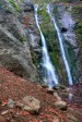
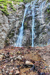
Image 1 of 3;
Click arrow to scroll or click image to enlarge
Lower tier of Pfeiffer Falls (46 ft)
Location: Big Sur, Pfeiffer Big Sur State Park, Monterey County
Stream: Pfeiffer Redwood Creek
Alternate Names:

Height: ~80 ft.
Access:   hike   nodog  
Distance: 1 mile (RT)
Elevation: 300 ft. (+300 ft.)
Season: Dec-May
Form:   tiered
Lat/Long:36.25694, -121.78056
Directions:Along Hwy #1 at Pfeiffer Big Sur State Park, 2 miles south of Big Sur (26 miles south of Carmel). Follow signs to Pfeiffer Falls trailhead in park.

Pfeiffer Redwood Creek has a small drainage, so Pfeiffer Falls is really only interesting after a lot of rain. However, I was somewhat surprised to find it flowing at all when we came here in Feb. 2007. We had not had any rain in California since mid December, and yet the waterfall was still flowing. I was only expecting a trickle at best. So it will probably be worth your while to see Pfeiffer Falls if you are in the area anytime from Dec-May.

The hike is a pretty one through a lovely Redwood forest, and it is easy. In fact, my 1 1/2 year old daughter made the hike all by herself (and back). I was very proud of her. It will probably be quite dark at the falls, so you will definitely need a tripod to take a good photo of it. The park is also quite popular, so it is recommended to arrive at the falls early in the morning.

As of summer of 2008, the easy trail to the waterfall has been closed. The only way to access it now is via the Valley View trail, which is a bit tougher (it is 3/4 mile one way and climbs 400 ft.). The reason for the closure is from the forest fire in 2008 that did a lot of damage to the trail. A sign indicates a new trail is being built, but it was supposed to be finished in 2012 and as of Jan 2013 it is still not completed.

Also worth noting is the upper falls. You can see them easily enough from the lower falls, though it is not so easy for taking a photo. They are immediately above the lower falls and about the same height (and indeed, they have the same segmented form as well). Since they are immediately above the lower falls, I consider this to be one single (tiered) waterfall, not two separate waterfalls. I think it would be easy enough to get up to them, however signs indicate it is not allowed.

2 Miles ESE Big Sur CA (Elev. 2103 ft)

Today
Partly sunny, with a high near 61. West wind 5 to 9 mph.
Tonight
Mostly cloudy, with a low around 48. North northwest wind 6 to 8 mph.
Saturday
Partly sunny, then gradually becoming sunny, with a high near 70. North northwest wind 8 to 13 mph.
Saturday Night
Increasing clouds, with a low around 49. North wind 18 to 21 mph, with gusts as high as 25 mph.
Sunday
Mostly sunny, with a high near 67. Northwest wind 15 to 21 mph.
Sunday Night
Mostly clear, with a low around 50.
Monday
Mostly sunny, with a high near 64.
Monday Night
Partly cloudy, with a low around 45.
Tuesday
Mostly sunny, with a high near 59.
Tuesday Night
Mostly cloudy, with a low around 44.
Wednesday
Mostly sunny, with a high near 57.
Wednesday Night
Mostly cloudy, with a low around 44.
Thursday
Mostly sunny, with a high near 56.

Get Google Maps directions to trailhead

Zoom out on map to see all nearby waterfalls:

Other waterfalls nearby:

Andrew Molera Falls 2.96 miles
Mill Creek Preserve Falls 7.65 miles
Pine Falls 7.86 miles
Pick Creek Falls 8.45 miles
Upper McWay Falls 8.88 miles
McWay Falls 8.98 miles
Canyon Falls 8.99 miles

Central Coast Waterfalls Home Page