|
|
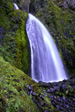
Easy |

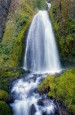
Image 1 of 2; Click arrow to scroll or click image to enlarge |
Location: Columbia River Gorge National Scenic Area, Multnomah Falls, Multnomah County Stream: Wahkeena Creek Alternate Names: Height: 242 ft. Access:   Distance: n/a Elevation: 100 ft. Season: year-round Form:  Lat/Long:45.57359, -122.12697 Directions:Along I-84, take exit 31 at the signed turnoff for Multnomah Falls (31 miles east of Portland). Drive 0.7 miles west of Multnomah Falls on the Columbia Gorge Scenic Hwy to the signed turnoff for Wahkeena Falls. |


Multnomah Falls OR (Elev. 200 ft)
TodaySunny, with a high near 69. Very windy, with an east northeast wind 24 to 30 mph, with gusts as high as 41 mph.
Tonight
Mostly clear, with a low around 49. Breezy, with an east northeast wind 18 to 21 mph, with gusts as high as 31 mph.
Saturday
Showers likely after 11am. Increasing clouds, with a high near 68. Breezy, with an east northeast wind 11 to 18 mph becoming southwest in the afternoon. Winds could gust as high as 25 mph. Chance of precipitation is 60%. New precipitation amounts between a tenth and quarter of an inch possible.
Saturday Night
Showers, mainly before 11pm. Low around 44. Breezy, with a west southwest wind 14 to 18 mph, with gusts as high as 26 mph. Chance of precipitation is 90%. New precipitation amounts between a tenth and quarter of an inch possible.
Sunday
Showers likely, mainly before 11am. Partly sunny, with a high near 59. Southwest wind around 11 mph, with gusts as high as 18 mph. Chance of precipitation is 60%.
Sunday Night
Mostly clear, with a low around 39.
Monday
Sunny, with a high near 68.
Monday Night
Partly cloudy, with a low around 47.
Tuesday
Mostly sunny, with a high near 70.
Tuesday Night
A chance of showers, mainly after 11pm. Mostly cloudy, with a low around 46.
Wednesday
A chance of showers. Partly sunny, with a high near 64.
Wednesday Night
A chance of showers. Mostly cloudy, with a low around 47.
Thursday
Showers likely. Mostly cloudy, with a high near 58.
| Fairy Falls | 0.27 miles | |
| Multnomah Falls | 0.61 miles | |
| Dutchman Falls | 0.97 miles | |
| Ecola Falls | 1.03 miles | |
| Weisendanger Falls | 1.04 miles | |
| Upper Coopey Falls | 2.09 miles | |
| Coopey Falls | 2.15 miles | |
| Triple Falls | 2.93 miles | |
| Oneonta Falls | 2.95 miles | |
| Middle Oneonta Falls | 3.00 miles | |
| Lower Oneonta Falls | 3.01 miles | |
| Upper Bridal Veil Falls | 3.05 miles | |
| Bridal Veil Falls | 3.11 miles | |
| Ponytail Falls | 3.29 miles | |
| Horsetail Falls | 3.29 miles | |
| Shepperds Dell Falls | 4.05 miles | |
| Latourell Falls | 5.48 miles | |
| Upper Latourell Falls | 5.82 miles | |
| Elowah Falls | 7.51 miles | |
| Upper McCord Creek Falls | 7.55 miles | |
| Wahclella Falls | 9.83 miles | |
| Munra Falls | 9.95 miles |
| Columbia River Gorge | Waterfalls Home Page |