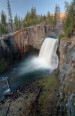
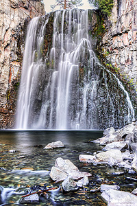
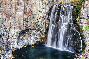
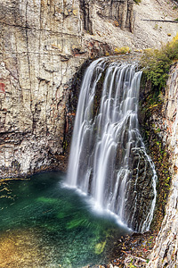
| Rainbow Falls | Easy |

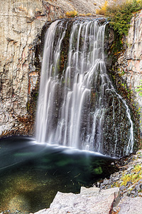
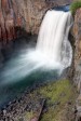
Image 1 of 9; Click arrow to scroll or click image to enlarge |
Location: Mammoth Lakes, Devils Postpile National Monument, Inyo National Forest, Madera County Stream: Middle Fork San Joaquin River Alternate Names: Height: 101 ft. Access:   Distance: 2.4 miles (RT) Elevation: 7700 ft. (-300 ft.) Season: Jun-Sep Form:  Lat/Long:37.60192, -119.08427 Directions:From Mammoth Lakes, drive 13 miles on Hwy 203 to Devils Postpile Natl. Monument. At the turnoff for the Devils Postpile (ranger station), continue 1.3 miles to the turnoff for the Rainbow Falls trailhead parking area. There is a fee to enter the Monument. There is also a mandatory shuttle bus unless you are camping or are handicapped. |


5 Miles WSW Mammoth Lakes CA (Elev. 7799 ft)
OvernightMostly cloudy, with a steady temperature around 36. Calm wind.
Wednesday
Rain likely, mainly between 11am and 2pm, then showers likely and possibly a thunderstorm after 2pm. Mostly cloudy, with a high near 55. Calm wind becoming southwest around 5 mph. Chance of precipitation is 70%. New rainfall amounts between a tenth and quarter of an inch, except higher amounts possible in thunderstorms.
Wednesday Night
A 50 percent chance of showers and thunderstorms before 11pm. Cloudy during the early evening, then gradual clearing, with a low around 31. North northeast wind around 5 mph, with gusts as high as 15 mph. New precipitation amounts between a tenth and quarter of an inch, except higher amounts possible in thunderstorms.
Thursday
A 30 percent chance of showers and thunderstorms after 11am. Mostly sunny, with a high near 58. Wind chill values as low as 29 early. Northeast wind around 5 mph, with gusts as high as 15 mph.
Thursday Night
A 10 percent chance of showers and thunderstorms before 11pm. Partly cloudy, with a low around 33. Northeast wind around 5 mph becoming calm in the evening.
Friday
A 40 percent chance of showers and thunderstorms after 11am. Mostly sunny, with a high near 59. Calm wind becoming southwest around 5 mph in the afternoon. Winds could gust as high as 20 mph.
Friday Night
A 20 percent chance of showers and thunderstorms before 11pm. Mostly cloudy, with a low around 34. Southwest wind 5 to 10 mph, with gusts as high as 20 mph.
Saturday
A chance of rain before 11am, then showers and possibly a thunderstorm between 11am and 5pm, then rain likely and possibly a thunderstorm after 5pm. Snow level 9200 feet lowering to 8200 feet in the afternoon . High near 46. Southwest wind 5 to 10 mph, with gusts as high as 30 mph. Chance of precipitation is 80%. New rainfall amounts between a quarter and half of an inch possible.
Saturday Night
Rain likely before 8pm, then snow likely. Mostly cloudy, with a low around 25. Southwest wind 5 to 10 mph becoming northwest after midnight. Winds could gust as high as 25 mph. Chance of precipitation is 60%. New precipitation amounts between a quarter and half of an inch possible.
Sunday
Snow likely before 2pm, then rain showers likely. Some thunder is also possible. Mostly cloudy, with a high near 42. West northwest wind 5 to 10 mph becoming north in the morning. Winds could gust as high as 25 mph. Chance of precipitation is 70%. New precipitation amounts between a quarter and half of an inch possible.
Sunday Night
A chance of rain and snow. Mostly cloudy, with a low around 26. North northeast wind 5 to 10 mph, with gusts as high as 25 mph. Chance of precipitation is 40%.
Monday
A chance of rain showers and snow. Some thunder is also possible. Snow level rising to 8600 feet in the afternoon. Partly sunny, with a high near 48. North wind 5 to 10 mph, with gusts as high as 20 mph. Chance of precipitation is 30%.
Monday Night
A 20 percent chance of rain. Snow level 9000 feet lowering to 8400 feet after midnight . Partly cloudy, with a low around 28. North northwest wind around 5 mph becoming northeast after midnight. Winds could gust as high as 20 mph.
| High Sierra | Waterfalls Home Page |