Best of the BestBest of the BestBest of the BestBest of the BestBest of the Best   Lower Eagle Falls Easy


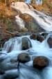
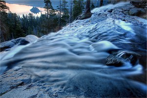
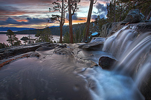
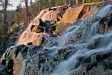
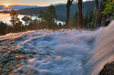
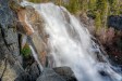
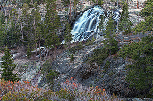
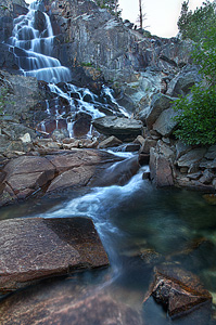
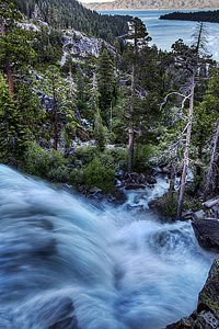
Image 1 of 9;
Click arrow to scroll or click image to enlarge
Lower section of Eagle Falls (82 ft.)
Location: South Lake Tahoe, Lake Tahoe Basin, El Dorado County
Stream: Eagle Creek
Alternate Names:

Height: 140 ft.
Access:   car   hike   nodog  
Distance: 2.2 miles (RT) (hike)
Elevation: 6600 ft. (-350 ft.)
Season: Apr-Jul
Form:   tiered
Lat/Long:38.95185, -120.11029
Directions:Along Hwy #89, 8.5 miles northwest of Hwy #50 junction, at South Lake Tahoe. Park at the Emerald Bay / Vikingsholm State Park ($5 fee).

Lower Eagle Falls (140 ft.) is seen from the roadside, at the Emerald Bay / Vikingsholm parking lot area (a half mile drive from the Eagle Falls picnic area). It is of course, a very popular tourist stop. In fact, it is incredibly difficult to get a parking spot here during the day (on weekends), so it is recommended to arrive early in the morning.

The waterfall is an awesome one, particularly in the spring, falling in two large drops. In the summer, once all the snow melts in the mountains, the waterfall reduces to a trickle. Spring is the time to visit for sure. The upper section of Eagle Falls is 58 ft. and the bottom is 82 ft. high. There are two ways to get to the base of Eagle Falls. A maintained trail leads from the parking lot at Emerald Bay State Park down to the lake. It is a fairly easy 1 mile hike down to the lakeside. Dogs are not allowed on this trail, unfortunately, as it is a state park. The second way to get down is to climb down the rocks from the roadside at the brink of the falls. This way is more difficult, but quicker and provides more views of the falls from up close. But please be careful, people have died here going over the falls.

7 Miles W South Lake Tahoe CA (Elev. 7867 ft)

Overnight
A 10 percent chance of snow showers after 5am. Snow level 8000 feet. Mostly cloudy, with a low around 36. Breezy, with a southwest wind 15 to 25 mph, with gusts as high as 45 mph.
Saturday
Snow showers, mainly after 8am. The snow could be heavy at times. Temperature falling to around 27 by 5pm. Windy, with a southwest wind 30 to 35 mph, with gusts as high as 60 mph. Chance of precipitation is 90%. New snow accumulation of 8 to 12 inches possible.
Saturday Night
Snow showers, mainly before 11pm. The snow could be heavy at times. Low around 20. Windy, with a southwest wind 20 to 30 mph, with gusts as high as 50 mph. Chance of precipitation is 90%. New snow accumulation of 3 to 5 inches possible.
Sunday
Mostly sunny, with a high near 31. Breezy, with a west wind 20 to 25 mph decreasing to 15 to 20 mph in the morning. Winds could gust as high as 40 mph.
Sunday Night
Partly cloudy, with a low around 23. Breezy, with a southwest wind 10 to 20 mph, with gusts as high as 30 mph.
Monday
Sunny, with a high near 40. Breezy, with a southwest wind 10 to 15 mph increasing to 20 to 25 mph in the afternoon. Winds could gust as high as 40 mph.
Monday Night
Partly cloudy, with a low around 27. Breezy.
Tuesday
Sunny, with a high near 44.
Tuesday Night
Clear, with a low around 30.
Wednesday
Sunny, with a high near 47.
Wednesday Night
Clear, with a low around 34.
Thursday
Sunny, with a high near 51.
Thursday Night
Clear, with a low around 38.

Get Google Maps directions to trailhead

Zoom out on map to see all nearby waterfalls:

Other waterfalls nearby:

Upper Eagle Falls 0.27 miles
Cascade Falls 1.27 miles
Eagle Lake Falls 1.30 miles
Upper Cascade Falls 1.56 miles
Lower Velma Lake Falls 1.70 miles
Azure Lake Falls 2.20 miles
Fontanillis Lake Falls 2.99 miles
Half Moon Lake Falls 4.37 miles
Gilmore Lake Falls 4.52 miles
Lower Lake Lois Falls 4.81 miles
Susie Lake Falls 5.03 miles
Meeks Creek Falls 5.16 miles
Upper Glen Alpine Falls 5.29 miles
Heather Lake Falls 5.30 miles
Far Glen Alpine Falls 5.34 miles
Lower Glen Alpine Falls 5.38 miles
Horseshoe Lake Falls 5.45 miles
Upper Horseshoe Lake Falls 5.76 miles
Lost Lake Falls 5.99 miles
McConnell Peak Falls 6.41 miles
Lower Waterfall Camp Falls 6.48 miles
West Waterfall Camp Falls 6.65 miles
Middle Waterfall Camp Falls 6.67 miles
East Waterfall Camp Falls 6.85 miles
Waterfall Camp Falls 6.85 miles
Gertrude Lake Falls 6.94 miles
Twin Lakes Falls 7.02 miles
Lower Gertrude Lake Falls 7.38 miles
Umpa Lake Falls 7.46 miles
Pyramid Peak Falls 7.51 miles
Pyramid Lake Falls 7.54 miles
Ropi Lake Falls 7.64 miles
Upper Crystal Basin Falls 7.66 miles
Gefo Lake Falls 7.93 miles
Upper Bassi Falls 8.11 miles
Crystal Basin Falls 8.14 miles
Lyons Creek Falls 8.15 miles
Horsetail Falls 8.41 miles
Jones Fork Silver Creek Falls 8.82 miles
Upper Miller Creek Falls 8.87 miles
Lower Miller Creek Falls 8.98 miles
Miller Creek Falls 8.99 miles
Upper Rocky Canyon Falls 9.46 miles
Lower Horsetail Falls 9.55 miles
Rocky Canyon Falls 9.82 miles

High Sierra Waterfalls Home Page