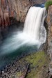
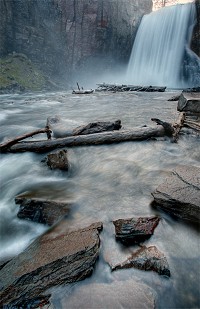
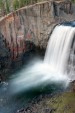
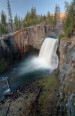
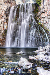
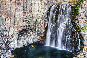
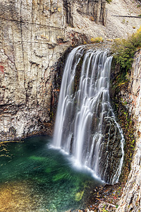
Rainbow Falls Easy


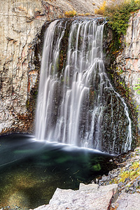
Image 1 of 9;
Click arrow to scroll or click image to enlarge
Location: Mammoth Lakes, Devils Postpile National Monument, Inyo National Forest, Madera County
Stream: Middle Fork San Joaquin River
Alternate Names:

Height: 101 ft.
Access:   hike   dog  
Distance: 2.4 miles (RT)
Elevation: 7700 ft. (-300 ft.)
Season: Jun-Sep
Form:   curtain
Lat/Long:37.60192, -119.08427
Directions:From Mammoth Lakes, drive 13 miles on Hwy 203 to Devils Postpile Natl. Monument. At the turnoff for the Devils Postpile (ranger station), continue 1.3 miles to the turnoff for the Rainbow Falls trailhead parking area. There is a fee to enter the Monument. There is also a mandatory shuttle bus unless you are camping or are handicapped.

Welcome to the best waterfall in the Eastern Sierra of California. No question about it. Rainbow Falls plunges 101 ft. off a cliff on the Middle Fork of the San Joaquin River. A magnificent sight indeed. I have been wanting to come here for a few years now. And finally this year, we made it out to see Rainbow Falls.It was worth the wait.

It is an easy 1.2 mile hike from the trailhead down to the falls, and is well-signed the whole way. My little 3 year old girl was able to hike down and back without any problems. Once down at the falls, there are a couple excellent overlooks of the waterfall. You can also follow the steep stairs down to the bottom of Rainbow Falls, which I highly recommend as well. Going back up is a bit of a huffer if you are not used to a climb like that. Do not forget to also go down to Lower Rainbow Falls, another half-mile on the trail, which many people bypass, but it is a nice little waterfall that should not be missed either.

For photography, Rainbow Falls is best photographed at around sunset. The light is a bit flat in the morning, and the sun does not get down into the canyon until much later in the morning. If you want to see the signature "rainbow" over the waterfall (its namesake feature), then you should arrive at the falls around noon-ish.

Although there were not any right at Rainbow Falls, I was surprised to see that there were quite a number of mosquitoes in the Monument when we were here in very early June. I suspect that means that later in the summer, this place will be swamped with the little buggers. Speaking of the Monument, you should also be sure to visit the Devils Postpile, which is located a couple miles up river, but is best accessed from the ranger station. Also, be sure to visit the 2nd best waterfall in the Eastern Sierra, namely Minaret Falls, which is also found just upstream.

5 Miles WSW Mammoth Lakes CA (Elev. 7799 ft)

This Afternoon
A 40 percent chance of showers and thunderstorms. Partly sunny, with a steady temperature around 59. West southwest wind around 5 mph, with gusts as high as 20 mph.
Tonight
A 20 percent chance of showers and thunderstorms before 11pm. Partly cloudy, with a low around 37. Southwest wind around 5 mph becoming calm in the evening. Winds could gust as high as 15 mph.
Sunday
Sunny, with a high near 59. Southwest wind 5 to 10 mph, with gusts as high as 30 mph.
Sunday Night
Mostly clear, with a low around 33. Southwest wind 5 to 10 mph, with gusts as high as 30 mph.
Monday
Sunny, with a high near 54. West southwest wind 5 to 10 mph, with gusts as high as 25 mph.
Monday Night
Partly cloudy, with a low around 31. West wind 5 to 10 mph becoming north northeast after midnight. Winds could gust as high as 25 mph.
Tuesday
Sunny, with a high near 58. North northeast wind around 5 mph becoming west in the afternoon. Winds could gust as high as 20 mph.
Tuesday Night
Mostly clear, with a low around 35. West southwest wind around 5 mph becoming calm in the evening. Winds could gust as high as 20 mph.
Wednesday
Sunny, with a high near 59. West southwest wind 5 to 10 mph, with gusts as high as 30 mph.
Wednesday Night
Mostly clear, with a low around 36. Southwest wind 5 to 10 mph, with gusts as high as 30 mph.
Thursday
Sunny, with a high near 59. Southwest wind 5 to 10 mph, with gusts as high as 30 mph.
Thursday Night
Partly cloudy, with a low around 35. Southwest wind 5 to 10 mph, with gusts as high as 30 mph.
Friday
A 10 percent chance of showers and thunderstorms. Snow level 8700 feet rising to 9700 feet in the afternoon. Mostly sunny, with a high near 56. Southwest wind 5 to 10 mph, with gusts as high as 30 mph.

Get Google Maps directions to trailhead

Zoom out on map to see all nearby waterfalls:

Other waterfalls nearby:

Lower Rainbow Falls 0.55 miles
Sotcher Lake Falls 1.54 miles
King Creek Falls 2.53 miles
Minaret Falls 2.70 miles
Middle King Creek Falls 2.87 miles
Upper King Creek Falls 3.39 miles
Upper Minaret Falls 3.97 miles
Twin Falls 4.01 miles
Far Upper Minaret Falls 4.14 miles
Mammoth Creek Falls 4.50 miles
Lower Mammoth Creek Falls 4.65 miles
Minaret Lake Falls 5.32 miles
Rosalie Lake Falls 6.33 miles
Shadow Lake Falls 6.86 miles
Shadow Creek Falls 6.93 miles
Upper Shadow Creek Falls 7.05 miles
Iron Creek Falls 7.37 miles
Ediza Lake Falls 7.38 miles
Lower Nydiver Lakes Falls 7.41 miles
Middle Fork San Joaquin River Falls 7.45 miles
Dike Creek Falls 7.52 miles
Upper Nydiver Lakes Falls 7.54 miles
Lower North Fork San Joaquin River Falls 7.55 miles
Lower Dike Creek Falls 7.56 miles
Middle North Fork San Joaquin River Falls 7.63 miles
Hemlock Crossing Falls 7.86 miles
Long Creek Falls 8.23 miles
East Garnet Lake Falls 8.37 miles
Garnet Lake Falls 8.62 miles
Middle Garnet Lake Falls 8.78 miles
Lower Garnet Lake Falls 8.83 miles
Ruby Lake Falls 9.25 miles
Upper North Fork San Joaquin River Falls 9.39 miles
North Fork San Joaquin River Falls 9.45 miles
Upper Lake Catherine Falls 9.50 miles
Middle Lake Catherine Falls 9.50 miles
Lake Catherine Falls 9.53 miles
Emerald Lake Falls 9.60 miles
Lower Bench Canyon Falls 9.67 miles
Ritter Lakes Falls 9.71 miles
Lower Twin Island Lakes Falls 9.75 miles
Thousand Island Lake Falls 9.79 miles
Twin Island Lakes Falls 9.97 miles

High Sierra Waterfalls Home Page