|
|
Easy |

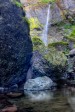
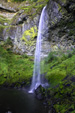
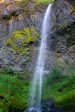
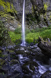
Image 1 of 5; Click arrow to scroll or click image to enlarge |
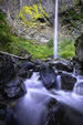
Location: Columbia River Gorge National Scenic Area, Bonneville, John B. Yeon State Park, Multnomah County Stream: McCord Creek Alternate Names: Height: 228 ft. Access:   Distance: 1.2 miles (RT) Elevation: 150 ft. (+150 ft.) Season: Mar-Jul Form:  Lat/Long:45.61218, -121.99469 Directions:Going east along I-84, take exit 37 to John B. Yeon State Park (37 miles east of Portland). |


2 Miles E Skamania WA (Elev. 154 ft)
TodayMostly sunny, with a high near 76. East wind 6 to 8 mph becoming west in the afternoon.
Tonight
A 20 percent chance of showers after midnight. Mostly cloudy, with a low around 51. West southwest wind 7 to 9 mph.
Saturday
Mostly cloudy, then gradually becoming sunny, with a high near 67. West southwest wind 9 to 14 mph, with gusts as high as 23 mph.
Saturday Night
Partly cloudy, with a low around 44. West wind 10 to 14 mph, with gusts as high as 24 mph.
Sunday
Partly sunny, with a high near 60. Breezy, with a west wind 11 to 15 mph, with gusts as high as 26 mph.
Sunday Night
Mostly cloudy, with a low around 46. Breezy.
Monday
A 20 percent chance of showers after 11am. Mostly cloudy, with a high near 59.
Monday Night
Showers likely, mainly after 11pm. Mostly cloudy, with a low around 50.
Tuesday
Showers likely, mainly before 11am. Partly sunny, with a high near 63.
Tuesday Night
A chance of showers before 11pm. Mostly cloudy, with a low around 47.
Wednesday
Mostly sunny, with a high near 72.
Wednesday Night
Mostly clear, with a low around 49.
Thursday
Sunny, with a high near 79.
| Upper McCord Creek Falls | 0.11 miles | |
| Wahclella Falls | 2.35 miles | |
| Munra Falls | 2.44 miles | |
| Upper Munra Falls | 2.91 miles | |
| Horsetail Falls | 4.22 miles | |
| Ponytail Falls | 4.23 miles | |
| Lower Oneonta Falls | 4.52 miles | |
| Middle Oneonta Falls | 4.54 miles | |
| Oneonta Falls | 4.62 miles | |
| Lower Ruckel Creek Falls | 4.63 miles | |
| Triple Falls | 4.74 miles | |
| Metlako Falls | 5.27 miles | |
| Lower Punch Bowl Falls | 5.32 miles | |
| Punch Bowl Falls | 5.33 miles | |
| Loowit Falls | 5.81 miles | |
| Skoonichuk Falls | 6.09 miles | |
| Tenas Falls | 6.25 miles | |
| Weisendanger Falls | 6.54 miles | |
| Dutchman Falls | 6.57 miles | |
| Ecola Falls | 6.60 miles | |
| Multnomah Falls | 6.91 miles | |
| Fairy Falls | 7.47 miles | |
| Dry Creek Falls | 7.47 miles | |
| Wahkeena Falls | 7.51 miles | |
| Tunnel Falls | 7.70 miles | |
| Eagle Creek Falls | 7.84 miles | |
| Upper Coopey Falls | 9.61 miles | |
| Coopey Falls | 9.67 miles |
| Columbia River Gorge | Waterfalls Home Page |