|
|
Easy |

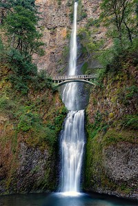
Image 1 of 1; Click arrow to scroll or click image to enlarge |
Location: Columbia River Gorge National Scenic Area, Multnomah Falls, Multnomah County Stream: Multnomah Creek Alternate Names: Height: 611 ft. Access:    Distance: n/a Elevation: 50 ft. Season: year-round Form:  Lat/Long:45.5762, -122.11603 Directions:Along I-84, take exit 31 at the signed turnoff for Multnomah Falls (31 miles east of Portland). |

Multnomah Falls OR (Elev. 200 ft)
OvernightRain, mainly before 4am. Low around 43. Calm wind. Chance of precipitation is 80%.
Thursday
A slight chance of rain before 7am, then a slight chance of showers after 2pm. Partly sunny, with a high near 64. East northeast wind 6 to 8 mph becoming west southwest in the afternoon. Chance of precipitation is 20%.
Thursday Night
Partly cloudy, with a low around 45. Southwest wind around 6 mph becoming light and variable after midnight.
Friday
Rain likely after 11am. Increasing clouds, with a high near 66. East northeast wind 7 to 9 mph becoming south southeast in the afternoon. Chance of precipitation is 60%. New precipitation amounts between a tenth and quarter of an inch possible.
Friday Night
Rain. Low around 47. North northeast wind around 9 mph becoming west southwest after midnight. Chance of precipitation is 100%. New precipitation amounts between a half and three quarters of an inch possible.
Saturday
Rain. High near 54. Chance of precipitation is 100%.
Saturday Night
Showers. Low around 44. Breezy. Chance of precipitation is 90%.
Sunday
Showers. Partly sunny, with a high near 53. Breezy.
Sunday Night
Showers. Mostly cloudy, with a low around 46. Breezy.
Monday
Rain before 11am, then showers and possibly a thunderstorm after 11am. Mostly cloudy, with a high near 53. Breezy.
Monday Night
Rain and possibly a thunderstorm. Mostly cloudy, with a low around 43.
Tuesday
Rain. Partly sunny, with a high near 54.
Tuesday Night
Rain. Mostly cloudy, with a low around 42.
| Dutchman Falls | 0.39 miles | |
| Weisendanger Falls | 0.48 miles | |
| Ecola Falls | 0.52 miles | |
| Fairy Falls | 0.60 miles | |
| Wahkeena Falls | 0.61 miles | |
| Triple Falls | 2.34 miles | |
| Oneonta Falls | 2.35 miles | |
| Middle Oneonta Falls | 2.39 miles | |
| Lower Oneonta Falls | 2.40 miles | |
| Ponytail Falls | 2.68 miles | |
| Horsetail Falls | 2.68 miles | |
| Upper Coopey Falls | 2.70 miles | |
| Coopey Falls | 2.76 miles | |
| Upper Bridal Veil Falls | 3.63 miles | |
| Bridal Veil Falls | 3.71 miles | |
| Shepperds Dell Falls | 4.65 miles | |
| Latourell Falls | 6.08 miles | |
| Upper Latourell Falls | 6.41 miles | |
| Elowah Falls | 6.91 miles | |
| Upper McCord Creek Falls | 6.95 miles | |
| Wahclella Falls | 9.22 miles | |
| Munra Falls | 9.34 miles | |
| Upper Munra Falls | 9.82 miles |
| Columbia River Gorge | Waterfalls Home Page |