| Nevada Falls | Strenuous |

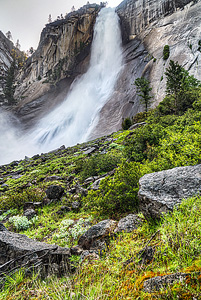
Image 1 of 3; Click arrow to scroll or click image to enlarge |
Location: Yosemite Village, Yosemite National Park, Mariposa County Stream: Merced River Alternate Names:
Height: 594 ft. |


If you continue up past Vernal Falls another mile, you will reach the top of spectacular Nevada Falls. It is a difficult hike to the top, but it is well worth the effort. There are many rocky steps to climb up to the top. These two waterfalls still have lots of water flow even in the summer, unlike others in the park. Come back down the John Muir Trail from the top of Nevada for a little change of scenery, instead of going back down the Mist Trail.
The official height of Nevada Falls is 594 ft. by the National Park Service. However, if you look at USGS Topo map and Google Earth, it seems closer to 450 ft., so it is possible that the NPS official height is incorrect. I have not been able to measure it myself because I was not able to get a good reading due to too much mist.
Get Google Maps directions to trailhead
Zoom out on map to see all nearby waterfalls:
Other waterfalls nearby:
| Silver Apron Falls | 0.50 miles | |
| Vernal Falls | 0.62 miles | |
| Lower Illilouette Falls | 1.42 miles | |
| Illilouette Falls | 1.71 miles | |
| Staircase Falls | 2.36 miles | |
| Tenaya Falls | 2.42 miles | |
| Royal Arch Cascade | 2.65 miles | |
| Snow Creek Falls | 2.80 miles | |
| Merced River Falls | 2.85 miles | |
| Sentinel Falls | 3.40 miles | |
| Clark Fork Falls | 3.55 miles | |
| Lehamite Falls | 3.56 miles | |
| Bunnell Cascade | 3.61 miles | |
| Lower Yosemite Falls | 3.86 miles | |
| Upper Yosemite Falls | 4.05 miles | |
| Lower Pywiack Cascade | 4.64 miles | |
| Pywiack Cascade | 4.90 miles | |
| Echo Creek Falls | 5.41 miles | |
| Horsetail Falls | 5.55 miles | |
| Silverlace Falls | 5.67 miles | |
| Bridalveil Falls | 6.10 miles | |
| Ribbon Falls | 6.20 miles | |
| Upper Tenaya Creek Falls | 6.62 miles | |
| Widows Tears | 7.18 miles | |
| Silver Strand Falls | 7.40 miles | |
| Lower Washburn Lake Falls | 8.08 miles | |
| Tioga Pass Falls | 8.77 miles | |
| Upper Washburn Lake Falls | 8.91 miles | |
| Sacred Pool Falls | 9.36 miles | |
| Cascades | 9.58 miles | |
| Tamarack Falls | 9.74 miles | |
| Wildcat Falls | 9.80 miles | |
| Merced Peak Fork Falls | 9.95 miles |
| High Sierra | Waterfalls Home Page |
 Home Info Contact Alpha Index Region Map Links Search Newsletter Blog Gallery Account Logout
 Photographs and content may not be used in any form without prior permission.
All rights reserved.